Aguja Guillaumet
| Aguja Guillaumet | |
|---|---|
East aspect | |
| Highest point | |
| Elevation | 2,574 m (8,445 ft)[1] |
| Prominence | 123 m (404 ft)[1] |
| Parent peak | Fitz Roy[1] |
| Isolation | 0.369 km (0.229 mi)[1] |
| Coordinates | 49°15′37″S 73°02′00″W / 49.26028°S 73.033329°W[1] |
| Naming | |
| Etymology | Henri Guillaumet |
| Geography | |
Aguja Guillaumet Location in Argentina Aguja Guillaumet Aguja Guillaumet (South America) Aguja Guillaumet Aguja Guillaumet (Southern Patagonia) | |
| Interactive map of Aguja Guillaumet | |
| Country | Argentina |
| Province | Santa Cruz |
| Protected area | Los Glaciares National Park |
| Parent range | Andes |
| Topo map | IGN 4769‑III El Chaltén |
| Geology | |
| Rock age | Cretaceous |
| Rock type | Granite |
| Climbing | |
| First ascent | 1965 |
Aguja Guillaumet is a mountain in Santa Cruz Province, Argentina.
Description
Aguja Guillaumet is a 2,574-meter-elevation (8,445-foot) summit in the Andes. The peak is located 1.5 kilometers (0.93 mile) northeast of Fitz Roy and 13 kilometers (8 miles) northwest of El Chaltén, in Los Glaciares National Park of Patagonia.[1] Precipitation runoff from the mountain's slopes drains to Viedma Lake. Topographic relief is significant as the summit rises 1,925 meters (6,315 ft) above Laguna Piedras Blancas in four kilometers (2.5 miles), and 1,175 meters (3,855 ft) above the North Fitz Roy Glacier in one kilometer (0.6 mi). The first ascent of the summit was made in 1965 by Carlos Comesaña and José Luis Fonrouge.[2] The toponym, which translates as Guillaumet Needle, was applied by Louis Lliboutry in 1952 to honor Henri Guillaumet (1902–1940), a French aviator who carried mail between Argentina and Chile.[3][4] The nearest higher peak is Aguja Mermoz, 0.475 kilometer (0.3 mile) to the southwest.[1]
Climbing
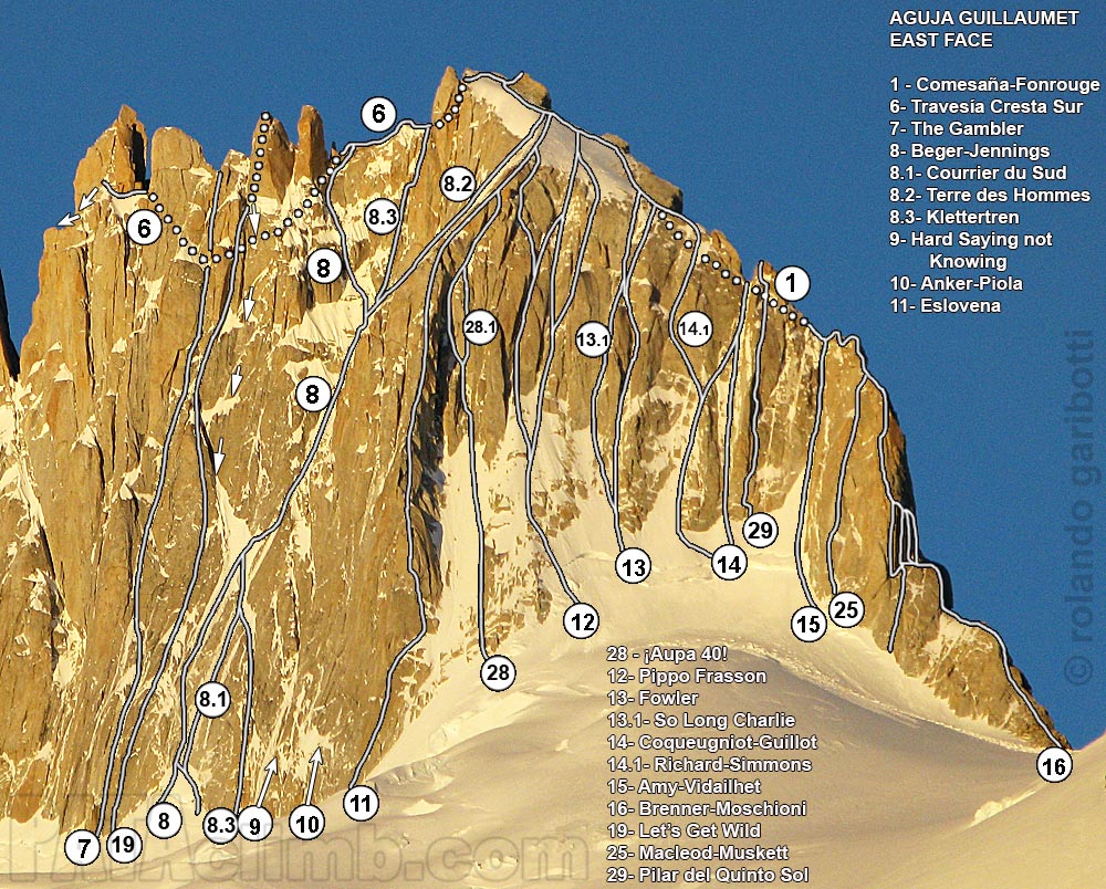
Established climbing routes with first ascents:[5]
- Original route – 1965 – class 5.10d – Carlos Comesaña, José Luis Fonrouge
- Amy-Vidailhet – 1968 – class 5.8 – Bernard Amy, Pierre Vidailhet
- Guillot-Conqueugniot – 1968 – class 5.8 – Joël Coqueugniot, François Guillot
- North Ridge – 1981 – Eduardo Brenner, Eduardo Moschioni[6]
- Hard Sayin’ Not Knowing – 2009 – Kate Rutherford, Michael Schaefer[7]
- Patagonian Werewolfs – 2012 – Marcos Costa, Sergey Dashkevitch[8]
Climate
According to the Köppen climate classification system, Aguja Guillaumet is located in a tundra climate zone with cold, snowy winters, and cool summers.[9] Weather systems are forced upward by the mountains (orographic lift), causing moisture to drop in the form of rain and snow. This climate supports the Piedras Blancas Glacier below the east slope of the peak and the North Fitz Roy Glacier to the west. The months of November through March offer the most favorable weather for visiting or climbing in this area.[10]
Gallery
See also
References
- ^ a b c d e f g "Aguja Guillaumet". Peakvisor.com. Retrieved January 21, 2026.
- ^ Aguja Guillaumet (2539 m.), Andeshandbook.org, Retrieved January 21, 2026.
- ^ Lliboutry, Louis. Le Massif du Fitz Roy: Carte au 1:50 000. Expédition Française au Fitz Roy, 1953.
- ^ Mountain Toponyms., PATAclimb.com, Retrieved January 21, 2026.
- ^ Aguja Gillaumet Rock Climbing, Mountainproject.com, Retrieved January 21, 2026.
- ^ Aguja Guillaumet, Patagonia, Planetmountain.com, Retrieved January 21, 2026.
- ^ South America, Argentina and Chile, Southern Patagonia, Aguja Guillaumet, Hard Sayin' Not Knowing, publications.americanalpineclub.org, Retrieved January 21, 2026.
- ^ South America, Argentina, Southern Patagonia, Chalten Massif, Aguja Guillaumet (2,579m), West Face, Patagonian Werewolfs, publications.americanalpineclub.org, Retrieved January 21, 2026.
- ^ Peel, M. C.; Finlayson, B. L.; McMahon, T. A. (2007). "Updated world map of the Köppen-Geiger climate classification" (PDF). Hydrology and Earth System Sciences. 11 (5): 1633–1644. Bibcode:2007HESS...11.1633P. doi:10.5194/hess-11-1633-2007. Archived (PDF) from the original on 2019-12-02. Retrieved 2025-11-07.
- ^ When is the Best Time to Visit Patagonia?, Wildernesstravel.com, Retrieved January 21, 2026.
External links
- Weather forecast: Aguja Guillaumet
- Aguja Guillaumet (photo): Pataclimb.com