Aguja Poincenot
| Aguja Poincenot | |
|---|---|
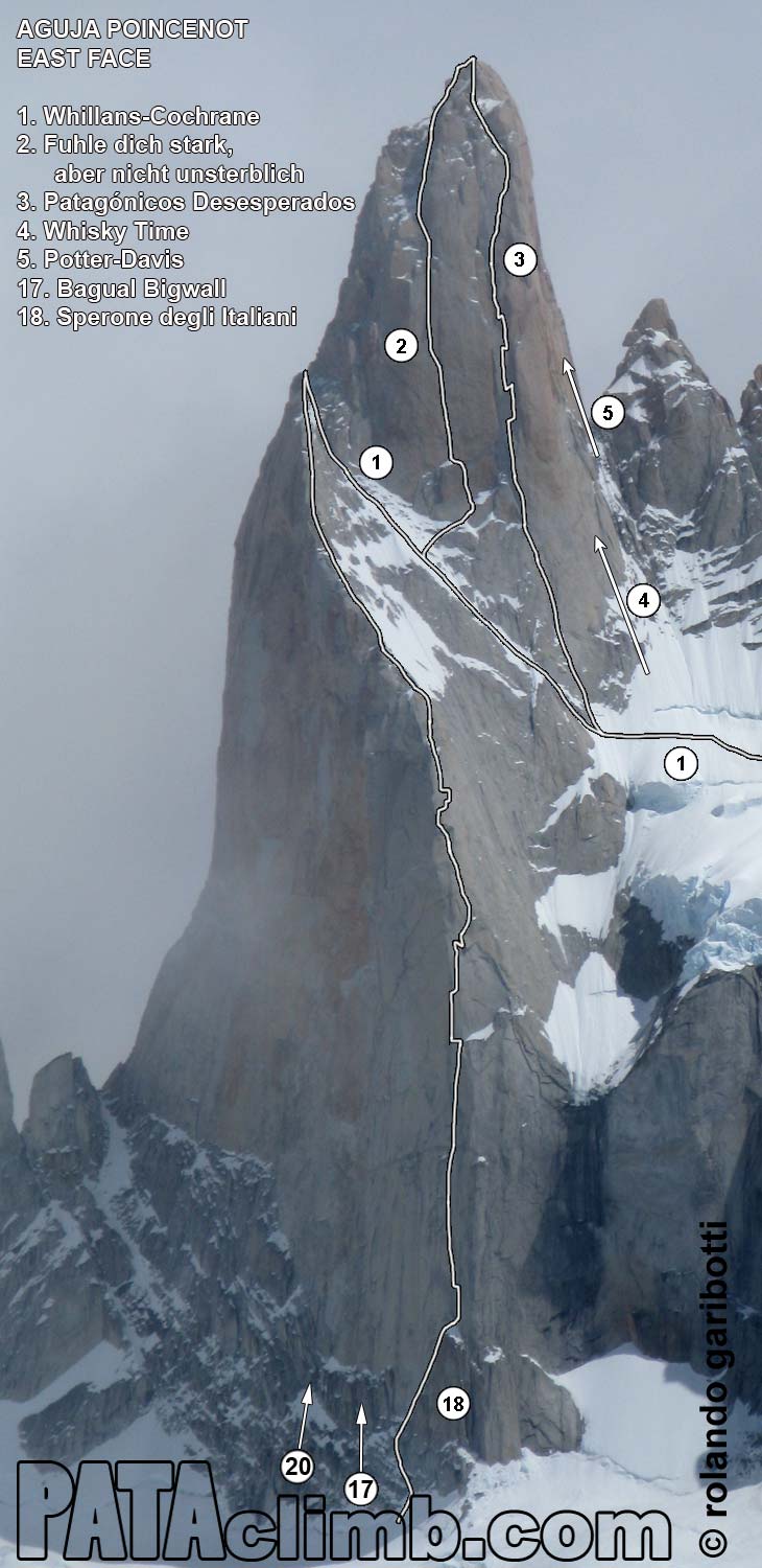
East face | |
| Highest point | |
| Elevation | 3,002 m (9,849 ft)[1][2] |
| Prominence | 392 m (1,286 ft)[3] |
| Parent peak | Fitz Roy[2] |
| Isolation | 1.09 km (0.68 mi)[2] |
| Coordinates | 49°16′52″S 73°02′26″W / 49.280973°S 73.040595°W[2] |
| Naming | |
| Etymology | Jacques Poincenot |
| Geography | |
Aguja Poincenot Location in Argentina Aguja Poincenot Aguja Poincenot (South America) Aguja Poincenot Aguja Poincenot (Southern Patagonia) | |
| Interactive map of Aguja Poincenot | |
| Country | Argentina |
| Province | Santa Cruz |
| Protected area | Los Glaciares National Park |
| Parent range | Andes |
| Topo map | IGN 4769‑III El Chaltén |
| Geology | |
| Rock age | Cretaceous |
| Rock type | Granite |
| Climbing | |
| First ascent | 1962 |
| Easiest route | East Face[4] |
Aguja Poincenot is a mountain in Santa Cruz Province, Argentina.
Description
Aguja Poincenot, also known as Cerro Poincenot, is a 3,002-meter-elevation (9,849-foot) summit in the Andes. The peak is located one kilometer (0.6 mile) south of Fitz Roy and 12 kilometers (7.5 miles) northwest of El Chaltén, in Los Glaciares National Park of Patagonia.[2] Precipitation runoff from the mountain's slopes drains to Viedma Lake. Topographic relief is significant as the summit rises 2,100 meters (6,890 ft) above Laguna Sucia in two kilometers (1.2 miles), and 2,030 meters (6,660 ft) above the Torre Glacier in two kilometers. The first ascent of the summit was made on January 31, 1962, by Don Whillans and Frank Cochrane via the east face and southeast ridge.[5] The toponym, which translates as Poincenot Needle, was applied by Louis Lliboutry in 1952 to honor French mountaineer Jacques Poincenot (1923–1951) who drowned in the Fitz Roy River while approaching Fitz Roy as a member of the first ascent expedition.[4][6][7] The nearest higher peak is Fitz Roy, 1.06 kilometers (0.68 mile) to the north.[2]
Climbing history
Established climbing routes with first ascents:[1]
- East face – 1962 – Don Whillans, Frank Cochrane
- Fonrouge-Rosasco (SW Face) – 1968 – José Luis Fonrouge, Alfredo Rosasco
- Carrington-Rouse (West Face) – 1977 – Rab Carrington, Alan Rouse
- 40º Gruppo Ragni (North Face) – 1986 – Paolo Vitali, Mario Panzeri, Marco Della Santa, Daniele Bosisio
- Neverending Story (SW Face) – 1987 – Fernado Cobo, Máximo Murcia
- Judgment Day (SW Face) – 1992 – Jay Smith, Steve Gerberding
- Whisky Time (East Face) – 1994 – Beat Eggler, Michal Pitelka
- Bagual Bigwall (SE Face) – 1995 – Makoto Ishibe, Alexandre Portela, Mike Schwitter, Andy Magg
- The Old Smuggler's Route (North Face) – 1996 – Jim Donini, Gregory Crouch
- Potter-Davis (North Face) – 2001 – Stephanie Davis, Dean Potter
- Southern Cross (West Face) – 2002 – Jonathan Copp, Dylan Taylor
- Bransby-Tresch (SW Face) – 2004 – Ben Bransby, Jvan Tresch
- Sperone degli Italiani (SE Face) – 2005 – Silvo Karo, Andrej Grmovšek
- The Sacrifice of the Mouse (SW Face) – 2006 – Dave Sharratt, Freddie Wilkinson
- DNV Direct (SW Face) – 2008 – Jason Kruk, Will Stanhope
- Banana Wall (North Face) – 2008 – Sacha Friedlin, Frédéric Maltais
- Fühle Dich stark, aber nicht unsterblich (East Face) – 2009 – Simon Gietl, Roger Schaeli
- Tango Viejo (West Face) – 2010 – Erich Gatt, Stephan Gatt
- Desperate Patagonians (East Face) – 2010 – Oriol Baro, Ramiro Calvo
- Benedetti-DeGregori (SW Face) – 2010 – Nicolás Benedetti, Esteban De Gregori
- Rise of the Machines (SW Face) – 2011 – Jens Holsten, Joel Kauffman, Mikey Schaefer
- Via Russo (SE Face) – 2012 – Sergey Dashkevich, Mikhail Devi, Evgeniy Dmitrienko, Arkadiy Seregi
- John Henry (North Face) – 2015 – Crystal Davis-Robbins, Jonathan Schaffer
- Invisible Line (North Face) – 2015 – Michal Brunner, Jindrich Hudecek
- The Power of Independent Trucking (North Face) – 2023 – Mateo Esposito, Ripley Boulianne[8]
- Pot (South Face) – 2024 – Luka Lindič, Luka Krajnc[9]
Climate
According to the Köppen climate classification system, Aguja Poincenot is located in a tundra climate zone with cold, snowy winters, and cool summers.[10] Weather systems are forced upward by the mountains (orographic lift), causing moisture to drop in the form of rain and snow. This climate supports the Piedras Blancas Glacier below the northeast slope of the peak, the Rio Blancas Glacier to the east, and the Torre Glacier to the west. The months of November through February offer the most favorable weather for visiting or climbing this peak.[11]
Gallery
See also
References
- ^ a b Aguja Poincenot (3002 m.), Andeshandbook.org, Retrieved January 16, 2026.
- ^ a b c d e f "Aguja Poincenot". Peakvisor.com. Retrieved January 16, 2026.
- ^ "Cerro Poincenot, Argentina". Peakbagger.com. Retrieved January 16, 2026.
- ^ a b John Biggar, The Andes, a Guide For Climbers, 2015, ISBN 9780953608751, p. 264.
- ^ Aguja Poincenot (ca. 3002m)., PATAclimb.com, Retrieved January 16, 2026.
- ^ Mountain Toponyms., PATAclimb.com, Retrieved January 16, 2026.
- ^ Lliboutry, Louis. Le Massif du Fitz Roy: Carte au 1:50 000. Expédition Française au Fitz Roy, 1953.
- ^ Aguja Poincenot, North Face, The Power of Independent Trucking, 2023, Ripley Boulianne, publications.americanalpineclub.org, Retrieved January 16, 2026.
- ^ Huge New Route Opened on Aguja Poincenot, Patagonia, Anthony Walsh, Climbing Magazine, Retrieved January 16, 2026.
- ^ Peel, M. C.; Finlayson, B. L.; McMahon, T. A. (2007). "Updated world map of the Köppen-Geiger climate classification" (PDF). Hydrology and Earth System Sciences. 11 (5): 1633–1644. Bibcode:2007HESS...11.1633P. doi:10.5194/hess-11-1633-2007. Archived (PDF) from the original on 2019-12-02. Retrieved 2025-11-07.
- ^ Cerro Poincenot – Climbing, Hiking & Mountaineering information, Mountain-forecast.com, Retrieved January 16, 2026.
External links
- Weather forecast: Cerro Poincenot
- Aguja Poincenot (photo): Pataclimb.com