N8 highway
Route 8 | ||||
|---|---|---|---|---|
Cebu South Road (Osmeña Boulevard) corner Cebu North Road (General Maxilom Avenue) in Cebu City along with an N8 reassurance marker | ||||
| Route information | ||||
| Maintained by the Department of Public Works and Highways (DPWH) | ||||
| Length | 174 km (108 mi) | |||
| Major junctions | ||||
| North end | N810 (Cebu North Road) in Danao | |||
| ||||
| South end | N830 (Natalio Bacalso Avenue) in Santander–Samboan boundary | |||
| Location | ||||
| Country | Philippines | |||
| Provinces | Cebu | |||
| Major cities | Danao, Mandaue, Cebu, Talisay, Naga, Carcar | |||
| Towns | Compostela, Liloan, Consolacion, Minglanilla, San Fernando, Sibonga, Argao, Dalaguete, Alcoy, Boljoon, Oslob, Santander | |||
| Highway system | ||||
| ||||
| ||||
National Route 8 (N8) is a 174-kilometer (108 mi) north-south major primary national route that forms part of the Philippine highway network in the province of Cebu. There are two highways that make up the road: the Cebu North Road and Natalio Bacalso Avenue (also known as the Cebu South Road). It runs from Danao to Santander.[1][2][3][4][5] The highway also forms part of the Philippine Nautical Highway System, particularly the Central Nautical Highway from Danao to Cebu City and Western Nautical Highway from Cebu City to Santander.
History
The highways of N8 were possibly constructed during the American period. The route's direct predecessor is Cebu Island's Highway 1 that existed during the 20th century.[6][7][8]
Around 2014–2017 national routes were added, two roads (Cebu North Road; Cebu City to Danao and Natalio Bacalso Avenue; Cebu City to Santander) assigned as National Route 8 (N8) by the Department of Public Works and Highways.
Route description
Danao to Cebu City
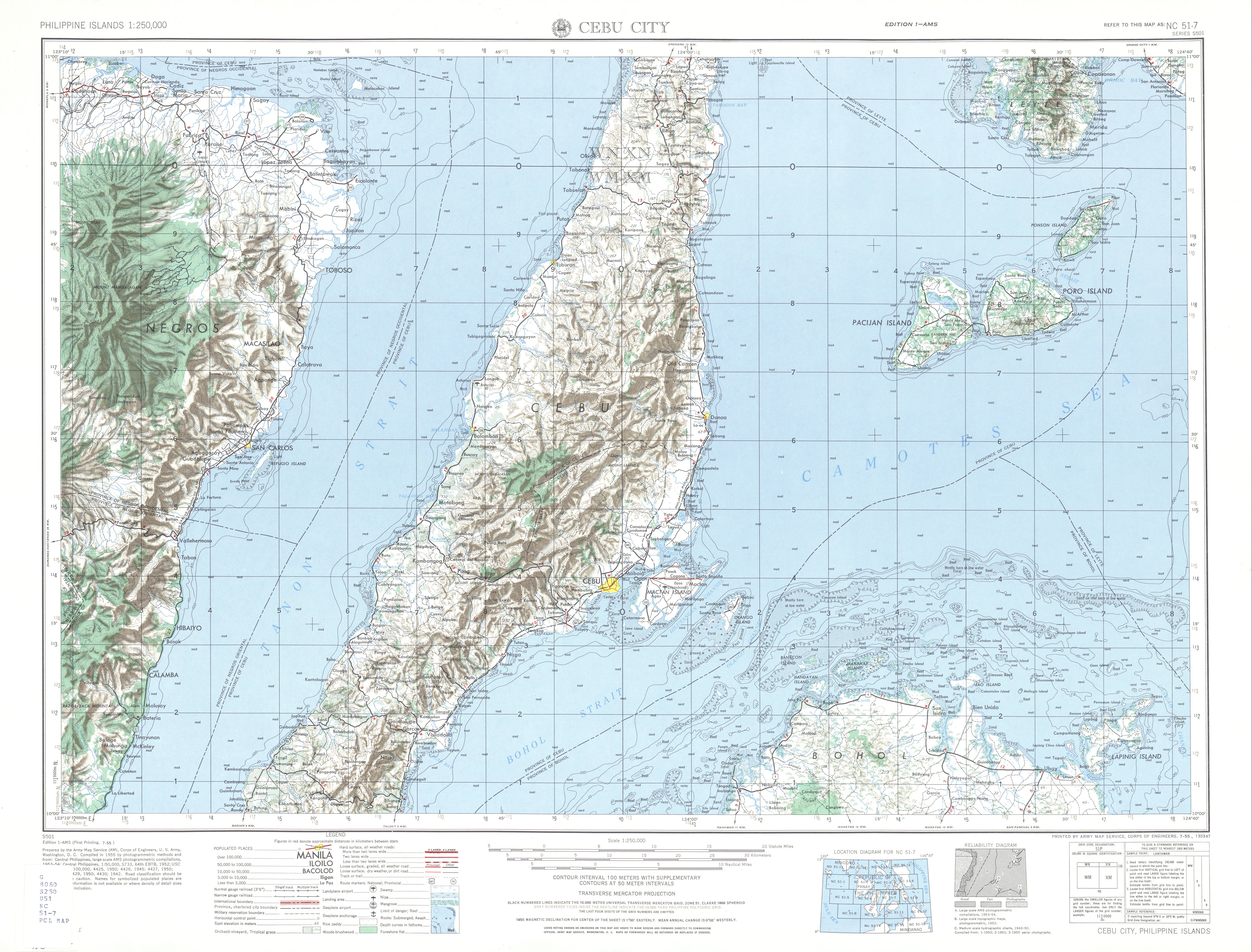
N8 begins at Cebu North Road at the route transitioning from the more rural N810 in Danao. It then passes the future terminus of the Metro Cebu Expressway. The route then traverses the towns of Compostela and Liloan, where it veers away from the eastern coast of Cebu towards Consolacion and Mandaue. In Mandaue, it is locally known as M.C. Briones Street and Lopez-Jaena Street. It then enters Cebu City, locally known as M.J. Cuenco Avenue.[9]
Cebu City
In Cebu City, the route turns northwest at a junction from M.J. Cuenco Avenue to General Maxilom Avenue. Cebu North Road continues east of the Fuente Osmeña Circle, shortly reaching the Cebu Provincial Capitol and kilometer 0. The southern portion of N8 starts west of the circle as Natalio Bacalso Avenue, with this section being part of the Osmeña Boulevard. The kilometer count branches off from the roundabout/Cebu North Road, on a direction opposite to it. After another junction, the boulevard becomes a tertiary route, turning N8 eastward as P. Del Rosario Street, this time being a six-lane divided highway. This section and the rest of Natalio Bacalso Avenue is alternatively called the Cebu South Road.
Cebu City to Santander
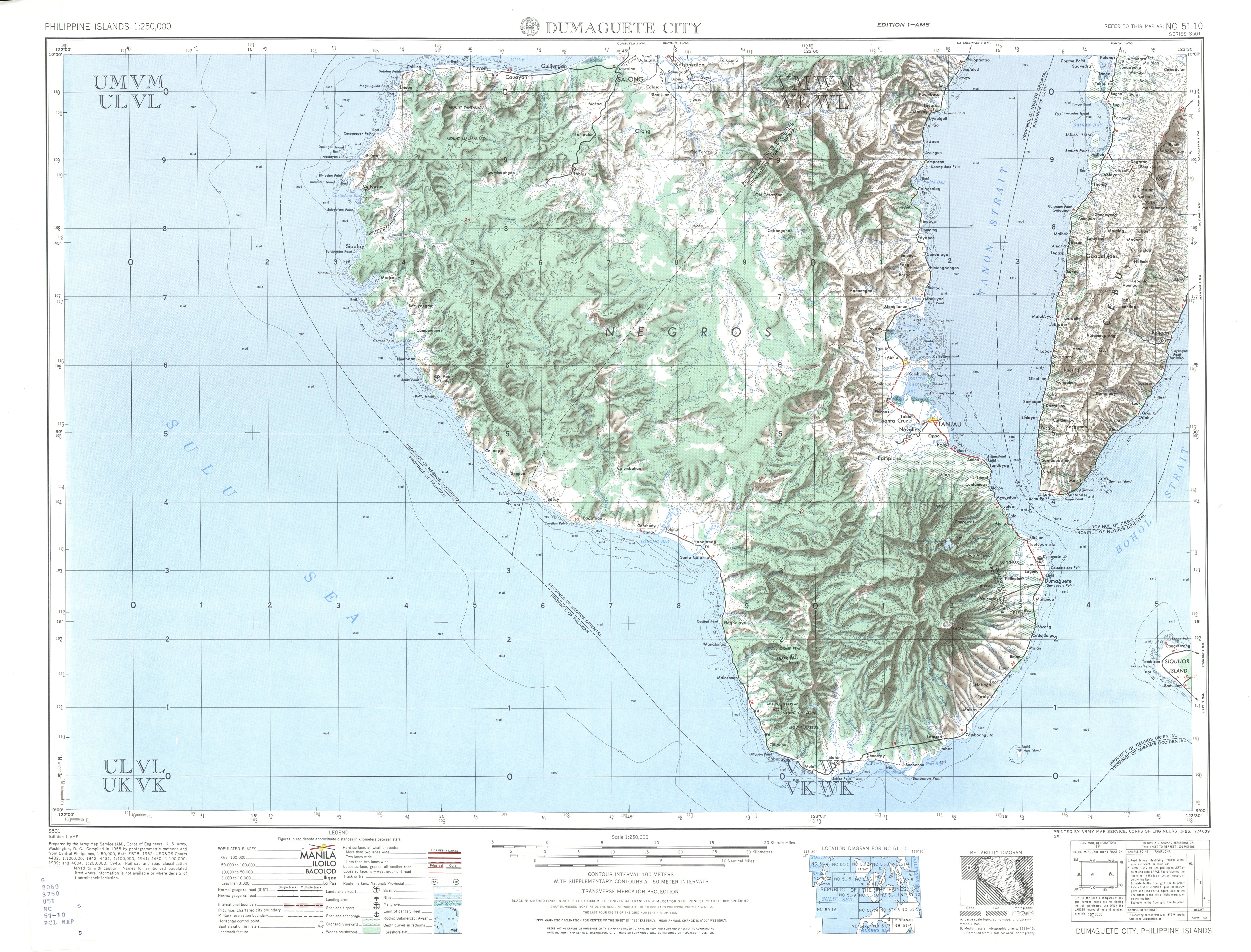
The route continues as Natalio Bacalso Avenue, traversing the southeastern coastal communities of Talisay, Minglanilla, Naga, San Fernando. After reaching Carcar, the route ends up in the Carcar City Circle, where east of it is Carcar–Barili Road (N83). The route becomes more rural as it traverses through the coastal municipalities of Sibonga, Argao, Dalaguete, Alcoy, Boljoon, Oslob, Santander, and Samboan.[1] In Samboan, it terminates at its transition with N830.
Intersections
Intersections are numbered by kilometer posts, with Cebu Provincial Capitol in Cebu City designated as kilometer 0.
| Province | City/Municipality | km | mi | Destinations | Notes | ||
|---|---|---|---|---|---|---|---|
| Cebu | Danao | 33 | 21 | N810 (Cebu North Road) | Northern terminus from a route change. | ||
| 32 | 20 | Metro Cebu Expressway | Under construction. Serves as a major metropolitan diversion route upon completion. | ||||
| Liloan | 18 | 11 | N840 (S.A. Lauron Avenue/Cansaga–Tayud Road) | Serves as diversion road. | |||
| Mandaue | Canduman–Cebu North Road | ||||||
| 8 | 5.0 | N841 (United Nations Avenue) | |||||
| 7 | 4.3 | N82 (A.C. Cortes Avenue) / M.L. Quezon Avenue | |||||
| A.S. Fortuna Avenue | |||||||
| M. Logarta Road / Hernan Cortes Avenue | |||||||
| Cebu City | 3 | 1.9 | N815 (Juan Luna Avenue/Pope John Paul II Avenue) | ||||
| N8 (Fuente Osmeña Road) | Northern terminus of Cebu South Road west of the road. Cebu North Road continues east and ends in the Provincial Capitol. | ||||||
| 0 | 0.0 | N. Escario Street | Kilometer zero. Southern terminus of Cebu North Road. | ||||
| Kilometer count reverses | |||||||
| Osmeña Boulevard | N8 is passed to P. Del Rosario Street | ||||||
| Vincent Rama–Tres de Abril Street | |||||||
| C. Padilla Street | |||||||
| Cebu Circumferential Road (Katipunan Street) | |||||||
| Bulacao River | Bulacao Bridge I and II | ||||||
| Cebu | Talisay | 9 | 5.6 | N825 (Rafael Rabaya Street/Toledo–Tabunok Road) | |||
| 11 | 6.8 | N840 (Cebu South Coastal Road) | Serves as diversion road. | ||||
| Naga | 21 | 13 | N81 (Naga–Toledo Road) | ||||
| Carcar | Carcar–Aloguinsan Road | ||||||
| 39 | 24 | N83 (Carcar–Barili Road) | roundabout | ||||
| Sibonga | Sibonga–Dumanjug Road | ||||||
| Argao | Argao–Moalboal Road – Moalboal | ||||||
| Dalaguete | Dalaguete–Mantalongon–Badian Road – Badian | ||||||
| Santander–Samboan boundary | 141 | 88 | N830 (Natalio Bacalso Avenue) | Southern terminus in a route change. | |||
1.000 mi = 1.609 km; 1.000 km = 0.621 mi
| |||||||
See also
References
- ^ a b "Cebu 2nd". Department of Public Works and Highways. Retrieved April 26, 2021.
- ^ "Cebu 4th". Department of Public Works and Highways. Retrieved April 26, 2021.
- ^ "Cebu 5th". Department of Public Works and Highways. Retrieved April 26, 2021.
- ^ "Cebu 6th". Department of Public Works and Highways. Retrieved April 26, 2021.
- ^ "Cebu City". Department of Public Works and Highways. Retrieved April 26, 2021.
- ^ NC 51-3 Bogo (Map). 1:250,000. Washington D.C.: Army Map Service, Corps of Engineers. 1954. Retrieved June 29, 2023.
- ^ NC 51-7 Cebu City (Map). 1:250,000. Washington D.C.: Army Map Service, Corps of Engineers. 1954. Retrieved June 29, 2023.
- ^ NC 51-10 Dumaguete City (Map). 1:250,000. Washington D.C.: Army Map Service, Corps of Engineers. 1954. Retrieved June 29, 2023.
- ^ "Road and Bridge Inventory". Department of Public Works and Highways. Retrieved June 29, 2023.