List of earthquakes in 2026
| Strongest magnitude | Mw 7.0 Malaysia |
|---|---|
| Deadliest | Mw 6.5 Mexico 2 deaths Mw 5.6 Pakistan 2 deaths |
| Total fatalities | 5 |
| Number by magnitude | |
| 9.0+ | 0 |
| 8.0–8.9 | 0 |
| 7.0–7.9 | 1 |
| 6.0–6.9 | 26 |
| 5.0–5.9 | 266 |
| 4.0–4.9 | 1,451 |
← 2025 | |
This is a list of earthquakes in 2026. Only earthquakes of magnitude 6 or above are included, unless they result in significant damage and/or casualties. All dates are listed according to UTC time. The maximum intensities are based on the Modified Mercalli intensity scale. Earthquake magnitudes are based on data from the United States Geological Survey (USGS).
Compared to other years
| Magnitude | 2016 | 2017 | 2018 | 2019 | 2020 | 2021 | 2022 | 2023 | 2024 | 2025 | 2026 |
|---|---|---|---|---|---|---|---|---|---|---|---|
| 8.0–9.9 | 0 | 1 | 1 | 1 | 0 | 3 | 0 | 0 | 0 | 1 | 0 |
| 7.0–7.9 | 16 | 6 | 16 | 9 | 9 | 16 | 11 | 19 | 10 | 15 | 1 |
| 6.0–6.9 | 131 | 104 | 117 | 135 | 112 | 138 | 116 | 128 | 89 | 129 | 23 |
| 5.0–5.9 | 1,561 | 1,456 | 1,688 | 1,500 | 1,329 | 2,070 | 1,599 | 1,633 | 1,408 | 1,984 | 266 |
| 4.0–4.9 | 13,700 | 11,541 | 12,785 | 11,899 | 12,513 | 15,069 | 14,022 | 14,450 | 12,668 | 16,023 | 1,451 |
| Total | 15,411 | 13,113 | 14,614 | 13,555 | 13,967 | 17,297 | 15,749 | 16,231 | 14,176 | 18,152 | 1,737 |
By death toll
| Rank | Death toll | Magnitude | Location | MMI | Depth (km) | Date | Event |
|---|---|---|---|---|---|---|---|
| 1 |
Listed are earthquakes with at least 10 reported fatalities.
By magnitude
| Rank | Magnitude | Death toll | Location | MMI | Depth (km) | Date | Event |
|---|---|---|---|---|---|---|---|
| 1 | 7.0 | 0 | Malaysia, Sabah offshore | V (Moderate) | 629.0 | February 22 | - |
Listed are earthquakes with at least 7.0 magnitude.
By month
January
| Strongest magnitude | Mw 6.5 Mexico |
|---|---|
| Deadliest | Mw 6.5 Mexico 2 deaths Mw 5.6 Pakistan 2 deaths |
| Total fatalities | 4 |
| Number by magnitude | |
| 9.0+ | 0 |
| 8.0–8.9 | 0 |
| 7.0–7.9 | 0 |
| 6.0–6.9 | 10 |
| 5.0–5.9 | 173 |
| 4.0–4.9 | 1,020 |
| Date | Country and location | Mw | Depth (km) | MMI | Notes | Casualties | |
|---|---|---|---|---|---|---|---|
| Dead | Injured | ||||||
| 1[1] | Southeast Indian Ridge | 6.0 | 10.0 | - | - | - | - |
| 2[2] | Mexico, Guerrero, 4 km (2.5 mi) NNW of Rancho Viejo | 6.5 | 18.0 | VII | 2 | 24 | |
| 4[3] | India, Assam, 13 km (8.1 mi) SW of Dhing | 5.2 | 35.0 | V | Three people injured in Morigaon and several homes damaged in the Morigaon-Nagaon area.[4] | - | 3 |
| 6[5] | Japan, Shimane, 18 km (11 mi) S of Matsue | 5.7 | 10.0 | VII | Fifteen people injured and 114 homes damaged in Hyōgo, Tottori, Shimane, Okayama and Hiroshima prefectures.[6] Ceiling panels in Yonago City Hall fell, fences and walls collapsed in Hōki, the wall of a building collapsed in Matsue, one house damaged in Tamano and a fire station cracked in Okayama.[7][8][9][10] | - | 15 |
| 7[11] | Philippines, Davao offshore, 16 km (9.9 mi) E of Baculin | 6.4 | 35.0 | VI | Aftershock of the 2025 Davao Oriental earthquakes. A chapel partially collapsed in Caraga.[12] | - | - |
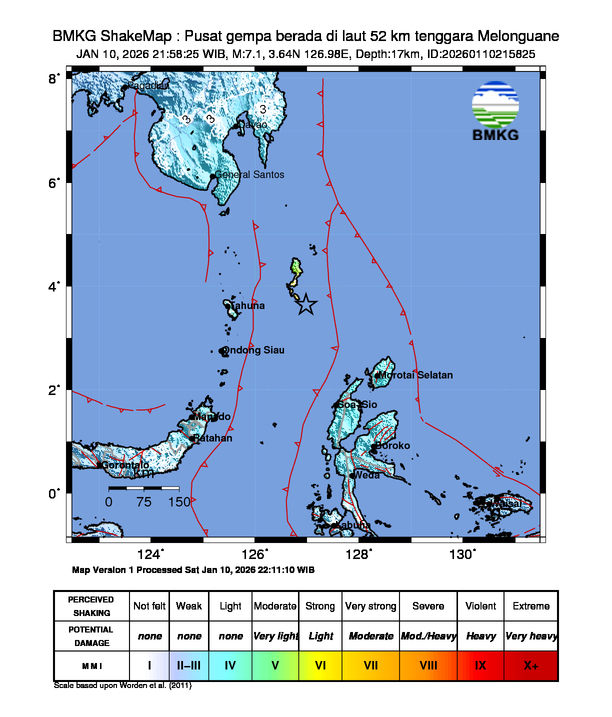
| 10[13] | Indonesia, North Sulawesi offshore, 245 km (152 mi) NNW of Tobelo | 6.4 | 31.0 | VII[14] | At least 14 structures damaged in Talaud Islands Regency.[15] | - | - |
| 13[16] | Russia, Sakhalin offshore, 133 km (83 mi) SE of Kurilsk | 6.2 | 35.8 | V | - | - | - |
| 16[17] | United States, Oregon offshore, 295 km (183 mi) W of Bandon | 6.0 | 10.0 | IV | - | - | - |
| 17[18] | Honduras, Cortés offshore, 12 km (7.5 mi) N of Cuyamel | 5.2 | 6.9 | V | At least 50 homes damaged in the Omoa area.[19] | - | - |
| 17[20] | Mexico, Guerrero, 7 km (4.3 mi) ESE of Barrio Nuevo de los Muertos | 4.9 | 10.0 | V | Aftershock of the 2026 Guerrero earthquake. Additional damage to homes in the San Marcos area.[21] | - | - |
| 19[22] | Pakistan, Gilgit-Baltistan, 47 km (29 mi) NNW of Barishal | 5.6 | 23.0 | VI | 2 | 5 | |
| 19[23] | China, Yunnan, 38 km (24 mi) SW of Zhaotong | 5.2 | 10.0 | IV | About 1,540 homes damaged and landslides and rockfalls occurred in Qiaojia County.[24] | - | - |
| 19[25] | New Caledonia, Loyalty Islands offshore, 260 km (160 mi) ESE of Tadine | 6.0 | 10.0 | - | - | - | - |
| 21[26] | Poland, Lower Silesian Voivodeship, 4 km (2.5 mi) WNW of Lubin | 3.5 | 1.0 | - | Two people injured at the Lubin mine.[27] | - | 2 |
| 21[28] | Japan, Volcano Islands offshore | 6.1 | 25.5 | III | - | - | - |
| 22[29] | Russia, Kamchatka offshore, 128 km (80 mi) S of Vilyuchinsk | 6.2 | 52.2 | V | Aftershock of the 2025 Kamchatka earthquake. | - | - |
| 23[30] | Indonesia, West Kalimantan, 156 km (97 mi) SSE of Simanggang, Malaysia | 4.8 | 10.0 | IV[31] | Some walls collapsed, several homes and a bridge damaged in Sintang Regency.[32][33] | - | - |
| 24[34] | Madagascar, Itasy, 11 km (6.8 mi) SW of Soavinandriana | 4.9 | 10.0 | IV | One person injured and two structures collapsed in the epicentral area.[35] | - | 1 |
| 26[36] | China, Gansu, 9 km (5.6 mi) ESE of Dianga | 5.5 | 10.0 | VII | One home collapsed, several others damaged and landslides occurred in Têwo County.[37] | - | - |
| 27[38] | Indonesia, East Java, 19 km (12 mi) SSW of Ponorogo | 5.7 | 127.0 | IV | Three people injured and one office building damaged in Trenggalek Regency.[39][40] Six homes damaged in Malang, Pacitan, and Ponorogo regencies.[41][42][43] One school damaged in Tulungagung Regency.[44] | - | 3 |
| 27[45] | Indonesia, Yogyakarta, 5 km (3.1 mi) SE of Pundong | 4.6 | 10.0 | III | Two people injured, 18 homes and one school damaged in Klaten Regency.[46] At least 12 buildings damaged in Gunung Kidul and Bantul regencies.[47][48] | - | 2 |
| 29[49] | South Georgia and the South Sandwich Islands offshore, South Sandwich Islands region | 6.0 | 68.1 | IV | - | - | - |
February
| Strongest magnitude | Mw 7.0 Malaysia |
|---|---|
| Deadliest | Mw 5.8 Indonesia 1 death |
| Total fatalities | 1 |
| Number by magnitude | |
| 9.0+ | 0 |
| 8.0–8.9 | 0 |
| 7.0–7.9 | 1 |
| 6.0–6.9 | 7 |
| 5.0–5.9 | 94 |
| 4.0–4.9 | 431 |
| Date | Country and location | Mw | Depth (km) | MMI | Notes | Casualties | |
|---|---|---|---|---|---|---|---|
| Dead | Injured | ||||||
| 1[50] | Iran, Bushehr offshore, 27 km (17 mi) WSW of Mohr | 5.2 | 10.0 | V | Some walls collapsed, windows shattered and damage to several transformers and electricity poles in Asaluyeh.[51] | - | - |
| 1[52] | Indonesia, Bali, 8 km (5.0 mi) E of Amlapura | 3.5 | 12.0 | - | At least two homes seriously damaged in Karangasem Regency.[53] | - | - |
| 2[54] | India, Jammu and Kashmir, 16 km (9.9 mi) WNW of Tsrār Sharīf | 4.8 | 10.0 | III | Many homes damaged in the Uri area.[55] | - | - |
| 4[56] | New Zealand, Kermadec Islands offshore | 6.1 | 184.2 | IV | - | - | - |
| 5[57] | Indonesia, East Java offshore, 94 km (58 mi) SW of Trenggalek | 5.8 | 40.0 | IV | 1 | 47 | |
| 8[58] | Chile, Tarapacá, 76 km (47 mi) ENE of La Tirana | 5.7 | 119.0 | V | One church severely damaged in Huara.[59] | - | - |
| 10[60] | Fiji region offshore | 6.2 | 510.9 | III | - | - | - |
| 12[61] | Chile, Coquimbo, 32 km (20 mi) SW of Ovalle | 6.2 | 36.9 | VI | One house damaged in Punitaqui.[62] Rockfalls occurred in the Agua Negra Pass.[63] | - | - |
| 12[64] | Afghanistan, Balkh, 23 km (14 mi) SW of Khulm | 4.5 | 10.0 | IV | Three people injured in Mazar-i-Sharif.[65] | - | 3 |
| 13[66] | Iran, Bushehr offshore, 34 km (21 mi) WSW of Mohr | 4.9 | 10.0 | V | Many homes damaged, some of them severely in the Asaluyeh area.[67] | - | - |
| 14[68] | Vanuatu, Sanma, 48 km (30 mi) of W of Port Olry | 6.4 | 43.0 | VI | - | - | - |
| 16[69] | Russia, Kamchatka offshore, 86 km (53 mi) ESE of Ozernovskiy | 6.0 | 43.0 | V | Aftershock of the 2025 Kamchatka earthquake. | - | - |
| 20[70] | Afghanistan, Panjshir, 38 km (24 mi) NE of Bazarak | 5.8 | 90.7 | IV | One person injured and three homes damaged in Takhar and Laghman provinces.[71] | - | 1 |
| 21[72] | Slovakia, Trnava, 10 km (6.2 mi) ESE of Šamorín | 4.1 | 10.0 | V | A chimney collapsed in Bratislava and several homes and buildings damaged in the Šamorín-Galanta-Dunajská Streda area.[73][74] | - | - |
| 22[75] | South of the Fiji Islands | 6.0 | 653.8 | II | - | - | - |
| 22[76] | Malaysia, Sabah offshore, 55 km (34 mi) NNW of Kota Belud | 7.0 | 629.0 | V | Strongest earthquake ever recorded in Malaysia.[77] | - | - |
| 23[78] | United States, Alaska offshore, 93 km (58 mi) SW of Nikolski | 6.1 | 14.0 | V | - | - | - |
| 25[79] | Tajikistan, Gorno-Badakhshan, 33 km (21 mi) N of Ishqoshim | 5.4 | 121.3 | IV | Two people injured by a landslide in Fayzabad, Afghanistan.[80] | - | 2 |
| 27[81] | Bangladesh, Khulna, 23 km (14 mi) SSE of Satkhira | 5.0 | 35.0 | VII | Three people injured and many homes, schools and mosques damaged in Satkhira District.[82][83] Some buildings and a road damaged in Kolkata, India.[84] | - | 3 |
| 27[85] | Azerbaijan, Shamakhi, 16 km (9.9 mi) NNW of Shamakhi | 4.8 | 10.0 | - | Dozens of homes and buildings damaged or destroyed in the Agsu-Shamakhi area.[86] | - | - |
March
| Strongest magnitude | Mw 6.6 Antarctica |
|---|---|
| Total fatalities | 0 |
| Number by magnitude | |
| 9.0+ | 0 |
| 8.0–8.9 | 0 |
| 7.0–7.9 | 0 |
| 6.0–6.9 | 9 |
| 5.0–5.9 | 11 |
| 4.0–4.9 | 36 |
| Date | Country and location | Mw | Depth (km) | MMI | Notes | Casualties | |
|---|---|---|---|---|---|---|---|
| Dead | Injured | ||||||
| 1[87] | Fiji region offshore | 6.3 | 596.3 | III | - | - | - |
| 2[88] | Japan, Volcano Islands offshore | 6.0 | 20.0 | - | - | - | - |
| 3[89] | Indonesia, Aceh offshore, 62 km (39 mi) SE of Sinabang | 6.2 | 18.0 | VI | - | - | - |
| 4[90] | Italy, Sicily offshore, 12 km (7.5 mi) ESE of Letojanni | 4.5 | 10.0 | V | Walls and roofs collapsed and at least 600 homes damaged in the Ragalna area.[91][92] | - | - |
| 4[93] | United States, Alaska offshore, 224 km (139 mi) ESE of Attu Station | 6.4 | 10.0 | VI | - | - | - |
| 6[94] | Solomon Islands, Makira-Ulawa offshore, 181 km (112 mi) SE of Kirakira | 6.3 | 8.7 | IV | - | - | - |
| 8[95] | Greece, Epirus, 2 km (1.2 mi) SSE of Rodotopi | 5.5 | 10.0 | VII | At least 140 homes damaged or destroyed, landslides occurred and power outages in the Dodoni-Ioannina-Seniko area.[96][97][98] | - | - |
| 9[99] | Turkey, Denizli, 10 km (6.2 mi) E of Buldan | 5.1 | 10.0 | V | Some old houses and buildings collapsed or damaged in the Buldan area.[100] | - | - |
| 9[101] | Italy, Campania offshore, 12 km (7.5 mi) W of Anacapri | 6.0 | 381.7 | III | - | - | - |
| 12[102] | Greece, Thessaly, 15 km (9.3 mi) SE of Anthiro | 5.1 | 10.0 | VII | Several buildings including a church damaged, landslides occurred and power outages in the Karditsa-Evrytania area.[103] | - | - |
| 13[104] | Turkey, Tokat, 16 km (9.9 mi) E of Erbaa | 5.3 | 10.0 | VII | Some people injured or hospitalized and minor damage in the Tokat area.[105] | - | Some |
| 13[106] | Chile, Atacama offshore, 85 km (53 mi) W of Vallenar | 6.3 | 10.0 | VI | One school damaged in Freirina.[107] | - | - |
| 14[108] | Netherlands, Drenthe, 4 km (2.5 mi) SSE of Assen | 2.9 | 3.0 | - | More than 630 buildings damaged in the Assen area.[109] | - | - |
| 14[110] | Indonesia, West Java, 9 km (5.6 mi) SE of Sukabumi | 4.1 | 10.0 | - | At least two homes collapsed and several buildings damaged in Sukabumi Regency.[111] One home damaged in Cianjur Regency.[112] | - | - |
| 17[113] | Cuba, Guantanamo offshore, 49 km (30 mi) SSw of Maisí | 5.8 | 11.6 | V | Facades collapsed and several homes damaged in Santiago de Cuba.[114] | - | - |
| 17[115] | Russia, Magadan, 32 km (20 mi) NNE of Ola | 4.9 | 10.0 | IV | Some buildings damaged, and power and water outages occurred in the Magadan area.[116] | - | - |
| 18[117] | Guatemala, Izabal, 15 km (9.3 mi) NNE of Los Amates | 5.0 | 10.0 | IV | The wall of a home collapsed in the Los Amates area.[118] | - | - |
| 20[119] | Antarctica, South Shetland Islands offshore | 6.6 | 4.9 | V | - | - | - |
| 20[120] | Vanuatu, Tafea offshore, 100 km (62 mi) WNW of Isangel | 6.1 | 10.0 | IV | - | - | - |
See also
- Earth sciences portal
- Lists of 21st-century earthquakes
- List of earthquakes 2021–present
- Lists of earthquakes by year
- Lists of earthquakes
References
- ^ ANSS. "M 6.0 - southeast Indian Ridge 2026". Comprehensive Catalog. U.S. Geological Survey.
- ^ ANSS. "M 6.5 - 4 km NNW of Rancho Viejo, Mexico 2026". Comprehensive Catalog. U.S. Geological Survey.
- ^ ANSS. "M 5.2 - 13 km SW of Dhing, India 2026". Comprehensive Catalog. U.S. Geological Survey.
- ^ "5.1-magnitude quake hits NE, 3 hurt in Assam". Times of India. 5 January 2026. Retrieved 5 January 2026.
- ^ ANSS. "M 5.7 - 18 km S of Matsue, Japan 2026". Comprehensive Catalog. U.S. Geological Survey.
- ^ "島根県東部を震源とする地震による被害及び 消防機関等の対応状況 (第10報)" (PDF). Fire and Disaster Management Agency (in Japanese). 8 January 2026. Retrieved 8 January 2026.
- ^ "ビル外壁や市役所の天井が落下…島根東部震源の地震で建物被害相次ぐ". Yomiuri Shimbun (in Japanese). 6 January 2026. Retrieved 6 January 2026.
- ^ "【鳥取・島根で震度5強】岡山県の被害 岡山市で高齢者1人が転倒し負傷など (6日午後2時現在)". Setonaikai Broadcasting (in Japanese). 6 January 2026. Retrieved 6 January 2026.
- ^ "松江で4人救急搬送など 各地でけが人相次ぐ 鳥取・島根で震度5強". Mainichi Shimbun (in Japanese). 6 January 2026. Retrieved 6 January 2026.
- ^ 日本放送協会 (2026-01-06). "【地震】各地のけが人・建物被害などの最新情報". NHKニュース (in Japanese). Retrieved 2026-01-06.
- ^ ANSS. "M 6.4 - 16 km ESE of Baculin, Philippines 2026". Comprehensive Catalog. U.S. Geological Survey.
- ^ Tocmo, Hermel (2026-01-08). "Chapel only structure damaged in Davao Oriental 6.4 quake, 173 aftershocks recorded". ABS-CBN. Retrieved 2026-01-08.
- ^ ANSS. "M 6.4 - 245 km NNW of Tobelo, Indonesia 2026". Comprehensive Catalog. U.S. Geological Survey.
- ^ "BMKG ShakeMap: 52 km tenggara Melonguane". BMKG (in Indonesian). 10 January 2026. Retrieved 10 January 2026.
- ^ Wahyu Wachid Anshory (2026-01-12). "Gempa Magnitudo 7,1 di Talaud Rusak 12 Rumah dan Dua Faskes, BNPB Pastikan Situasi Terkendali". Kompas.com. Retrieved 2026-01-12.
- ^ ANSS. "M 6.2 - 133 km SE of Kuril'sk, Russia 2026". Comprehensive Catalog. U.S. Geological Survey.
- ^ ANSS. "M 6.0 - 295 km W of Bandon, Oregon 2026". Comprehensive Catalog. U.S. Geological Survey.
- ^ ANSS. "M 5.2 - 12 km N of Cuyamel, Honduras 2026". Comprehensive Catalog. U.S. Geological Survey.
- ^ "Al menos 50 viviendas afectadas por sismo de 5.7 registrado en Omoa" (in Spanish). Proceso.hn. January 17, 2026. Retrieved January 18, 2026.
- ^ ANSS. "M 4.9 - 7 km ESE of Barrio Nuevo de los Muertos, Mexico 2026". Comprehensive Catalog. U.S. Geological Survey.
- ^ "Se agravan los daños en viviendas de San Marcos tras nuevo sismo" (in Spanish). Sur Acapulco. January 17, 2026. Retrieved January 17, 2026.
- ^ ANSS. "M 5.6 - 47 km NNW of Barishal, Pakistan 2026". Comprehensive Catalog. U.S. Geological Survey.
- ^ ANSS. "M 5.2 - 38 km SW of Zhaotong, China 2026". Comprehensive Catalog. U.S. Geological Survey.
- ^ "云南巧家5.1级地震:1540间民房受损,救灾工作有序开展" (in Chinese). Sina Corporation. January 20, 2026. Retrieved January 21, 2026.
- ^ ANSS. "M 6.0 - 260 km ESE of Tadine, New Caledonia 2026". Comprehensive Catalog. U.S. Geological Survey.
- ^ "Earthquake information". EMSC-CSEM. 21 January 2026. Retrieved 23 January 2026.
- ^ "Silne wstrząsy w kopalni Lubin. Dwóch górników zostało rannych" (in Polish). Naszemiasto.pl. 21 January 2026. Retrieved 23 January 2026.
- ^ ANSS. "M 6.1 - Volcano Islands, Japan region 2026". Comprehensive Catalog. U.S. Geological Survey.
- ^ ANSS. "M 6.2 - 128 km S of Vilyuchinsk, Russia 2026". Comprehensive Catalog. U.S. Geological Survey.
- ^ ANSS. "M 4.8 - 156 km SSE of Simanggang, Malaysia 2026". Comprehensive Catalog. U.S. Geological Survey.
- ^ "Gempa Magnitudo 4,8 Mengguncang Sekadau Kalimantan Barat" (in Indonesian). Aktual.co.id. January 23, 2026. Retrieved January 26, 2026.
- ^ "Gempa M 4,8 di Sintang, Rumah Rusak-Jembatan Bergeser" (in Indonesian). Detik.com. January 23, 2026. Retrieved January 23, 2026.
- ^ "Gempa Rusak Sejumlah Bangunan di Kayan Hilir" (in Indonesian). Radio Republik Indonesia. January 23, 2026. Retrieved January 23, 2026.
- ^ ANSS. "M 4.9 - 11 km SW of Soavinandriana, Madagascar 2026". Comprehensive Catalog. U.S. Geological Survey.
- ^ "Séisme dans la région d'Itasy à Madagascar : deux maisons endommagées et un enfant blessé" (in French). Le Quotidien. January 24, 2026. Retrieved January 25, 2026.
- ^ ANSS. "M 5.5 - 9 km ESE of Dianga, China 2026". Comprehensive Catalog. U.S. Geological Survey.
- ^ "甘南迭部县发生5.5级地震 部分房屋出现裂缝" (in Chinese). China News Service. January 26, 2026. Retrieved January 26, 2026.
- ^ ANSS. "M 5.7 - 19 km SSW of Ponorogo, Indonesia 2026". Comprehensive Catalog. U.S. Geological Survey.
- ^ "Gempa Pacitan, Gedung Rusak Ringan dan Sebagian Perjalanan KA Dihentikan Sementara" (in Indonesian). Kompas.id. 27 January 2026. Retrieved 27 January 2026.
- ^ "Gempa 5,7 M Guncang Trenggalek, Atap Kantor Kecamatan Dongko Rusak, Tiga Orang Luka Ringan" (in Indonesian). Kabar Trenggalek. January 27, 2026. Retrieved January 27, 2026.
- ^ "Gempa M 5,7 di Trenggalek Akibatkan Dua Rumah di Malang Rusak" (in Indonesian). Suara Jatim Post. January 27, 2026. Retrieved January 27, 2026.
- ^ "Dampak Gempa di Pacitan: 2 Rumah Warga Rusak, Dinding Runtuh dan Retak" (in Indonesian). Kompas. January 27, 2026. Retrieved January 27, 2026.
- ^ "2 Rumah di Ngrayun Ponorogo Alami Rusak Imbas Gempa Pacitan" (in Indonesian). Kompas. January 27, 2026. Retrieved January 27, 2026.
- ^ "Dampak Gempa Pacitan di Tulungagung, SDN 1 Talunkulon Retak pada Tembok dan Lantai". Suryamalang.com (in Indonesian). Retrieved 2026-01-28.
- ^ ANSS. "M 4.6 - 5 km SE of Pundong, Indonesia 2026". Comprehensive Catalog. U.S. Geological Survey.
- ^ "Data BPBD: 18 Rumah dan Satu Sekolah di Klaten Rusak Akibat Gempa Bantul" (in Indonesian). Suaramerdeka. 28 January 2026. Retrieved 29 January 2026.
- ^ "10 Bangunan di Gunungkidul Rusak akibat Gempa Bantul" (in Indonesian). Detik.com. 27 January 2026. Retrieved 27 January 2026.
- ^ "BPBD Bantul data dua rumah rusak dampak gempa bumi magnitudo 4,4" (in Indonesian). Antaranews. 27 January 2026. Retrieved 27 January 2026.
- ^ ANSS. "M 6.0 - South Sandwich Islands region 2026". Comprehensive Catalog. U.S. Geological Survey.
- ^ ANSS. "M 5.2 - 27 km WSW of Mohr, Iran 2026". Comprehensive Catalog. U.S. Geological Survey.
- ^ "گزارش اولیه از خسارت زلزله صبح امروز یکشنبه" (in Persian). Asriran. 1 February 2026. Retrieved 1 February 2026.
- ^ "Earthquake information". EMSC-CSEM. 1 February 2026. Retrieved 3 February 2026.
- ^ "Karangasem Diguncang Gempa, Pondasi Dapur di Bunutan Jebol, Kerugian Capai Puluhan Juta" (in Indonesian). Tribunnews. 3 February 2026. Retrieved 3 February 2026.
- ^ ANSS. "M 4.8 - 16 km WNW of Tsrār Sharīf, India 2026". Comprehensive Catalog. U.S. Geological Survey.
- ^ "زلزلہ سے کئی مکانوں میں شگاف" (in Urdu). Kashmir Uzma. 3 February 2026. Retrieved 5 February 2026.
- ^ ANSS. "M 6.1 - Kermadec Islands, New Zealand 2026". Comprehensive Catalog. U.S. Geological Survey.
- ^ ANSS. "M 5.8 - 94 km SW of Trenggalek, Indonesia 2026". Comprehensive Catalog. U.S. Geological Survey.
- ^ ANSS. "M 5.7 - 76 km ENE of La Tirana, Chile 2026". Comprehensive Catalog. U.S. Geological Survey.
- ^ Fuentes, Samuel (8 February 2026). "Histórica parroquia de Tarapacá sufrió desprendimiento de material tras fuerte sismo en el norte" (in Spanish). Biobio Chile. Retrieved 9 February 2026.
- ^ ANSS. "M 6.2 - Fiji region 2026". Comprehensive Catalog. U.S. Geological Survey.
- ^ ANSS. "M 6.2 - 32 km SW of Ovalle, Chile 2026". Comprehensive Catalog. U.S. Geological Survey.
- ^ Paillafil, Sebastián (12 February 2026). "Con grietas en sus paredes: Estos fueron los daños que sufrió casa en Punitaqui tras fuerte sismo" (in Spanish). Mega.cl. Retrieved 12 February 2026.
- ^ "En el Paso de Agua Negra, impresionante derrumbe de rocas tras el fuerte sismo en Chile" (in Spanish). Tiempo de San Juan. 12 February 2026. Retrieved 12 February 2026.
- ^ ANSS. "M 4.5 - 23 km SW of Khulm, Afghanistan 2026". Comprehensive Catalog. U.S. Geological Survey.
- ^ "Three hurt jumping from building amid earthquake in Balkh". Ariana Television Network. 13 February 2026. Retrieved 13 February 2026.
- ^ ANSS. "M 4.9 - 34 km WSW of Mohr, Iran 2026". Comprehensive Catalog. U.S. Geological Survey.
- ^ "زلزله ۴.۷ ریشتری عسلویه باعث خسارت شد". Islamic Republic News Agency (in Persian). 13 February 2026. Retrieved 13 February 2026.
- ^ ANSS. "M 6.4 - 48 km W of Port-Olry, Vanuatu 2026". Comprehensive Catalog. U.S. Geological Survey.
- ^ ANSS. "M 6.0 - 86 km ESE of Ozernovskiy, Russia 2026". Comprehensive Catalog. U.S. Geological Survey.
- ^ ANSS. "M 5.8 - 38 km NE of Bāzārak, Afghanistan 2026". Comprehensive Catalog. U.S. Geological Survey.
- ^ "Afghanistan quake causes no 'serious' damage, injuries: official". Arab News. Agence France Presse. 21 February 2026. Retrieved 21 February 2026.
- ^ ANSS. "M 4.1 - 10 km ESE of Šamorín, Slovakia 2026". Comprehensive Catalog. U.S. Geological Survey.
- ^ "Popraskané omietky, rozbité sklo a poškodené strechy: Toto sú následky a škody po zemetrasení". iMeteo.sk (in Slovak). 21 February 2026. Retrieved 23 February 2026.
- ^ "Sobotné zemetrasenie poškodilo 350-ročný katolícky kostol v obci Báč". Teraz.sk (in Slovak). 23 February 2026. Retrieved 23 February 2026.
- ^ ANSS. "M 6.0 - south of the Fiji Islands 2026". Comprehensive Catalog. U.S. Geological Survey.
- ^ ANSS. "M 7.0 - 55 km NNW of Kota Belud, Malaysia 2026". Comprehensive Catalog. U.S. Geological Survey.
- ^ "Sabah quake strongest to hit Malaysia in recent memory". Borneo Bulletin. 24 February 2026. Retrieved 26 February 2026.
- ^ ANSS. "M 6.1 - 93 km SW of Nikolski, Alaska 2025". Comprehensive Catalog. U.S. Geological Survey.
- ^ ANSS. "M 5.4 - 33 km N of Ishqoshim, Tajikistan 2026". Comprehensive Catalog. U.S. Geological Survey.
- ^ "زلزله 5.4 ریشتری مناطق مرزی افغانستان و تاجیکستان را لرزاند؛ دو تن در بدخشان زخمی شدند". Afghan Voice Agency (in Persian). 25 February 2026. Retrieved 26 February 2026.
- ^ ANSS. "M 5.0 - 23 km SSE of Sātkhira, Bangladesh 2026". Comprehensive Catalog. U.S. Geological Survey.
- ^ "ভূমিকম্পের উৎপত্তিস্থল সাতক্ষীরা, আতঙ্কে আহত ৩". Janakantha (in Bengali). 27 February 2026. Retrieved 27 February 2026.
- ^ "ভূমিকম্পে শ্যামনগরের বহু ভবনে ফাটল, আহত ৩". Bd-bulletin.com (in Bengali). 27 February 2026. Retrieved 28 February 2026.
- ^ "Earthquake in Bangladesh jolts Kolkata, adjacent districts". Millenium Post. 27 February 2026. Retrieved 28 February 2026.
- ^ ANSS. "M 4.8 - 16 km NNW of Shamakhi, Azerbaijan 2026". Comprehensive Catalog. U.S. Geological Survey.
- ^ "Earthquake caused serious damage to houses in Shamakhi and Agsu - There are destructions". Modern.az. 3 March 2026. Retrieved 3 March 2026.
- ^ ANSS. "M 6.3 - Fiji region 2026". Comprehensive Catalog. U.S. Geological Survey.
- ^ ANSS. "M 6.0 - Volcano Islands, Japan region 2026". Comprehensive Catalog. U.S. Geological Survey.
- ^ ANSS. "M 6.2 - 62 km SE of Sinabang, Indonesia 2026". Comprehensive Catalog. U.S. Geological Survey.
- ^ ANSS. "M 4.5 - 12 km ESE of Letojanni, Italy 2026". Comprehensive Catalog. U.S. Geological Survey.
- ^ "Terremoto nel Catanese: danni e crolli a Ragalna VIDEO". Rai News (in Italian). 4 March 2026. Retrieved 4 March 2026.
- ^ "Sindaco di Ragalna, '600 segnalazioni di danni importanti a case private'". ANSA (in Italian). 4 March 2026. Retrieved 4 March 2026.
- ^ ANSS. "M 6.4 - 224 km ESE of Attu Station, Alaska 2026". Comprehensive Catalog. U.S. Geological Survey.
- ^ ANSS. "M 6.3 - 181 km SE of Kirakira, Solomon Islands 2026". Comprehensive Catalog. U.S. Geological Survey.
- ^ ANSS. "M 5.5 - 2 km SSE of Rodotópi, Greece 2026". Comprehensive Catalog. U.S. Geological Survey.
- ^ "Σεισμός στη Θεσπρωτία: Κατολίσθηση στην Εγνατία, ρωγμές σε σπίτια – Τι λένε οι σεισμολόγοι". Taxidromos (in Greek). 8 March 2026. Retrieved 8 March 2026.
- ^ "Κλειστά σήμερα τα σχολεία στην Ήπειρο μετά τον ισχυρό σεισμό 5,3 Ρίχτερ - Ζημιές σε σπίτια και ναούς". CNN Greece (in Greek). 9 March 2026. Retrieved 9 March 2026.
- ^ "Σεισμός στην Ήπειρο: Τα 5,3 Ρίχτερ «λάβωσαν» τη Δωδώνη, 140 κτίρια με σημαντικές ζημιές (εικόνες)". Dnews (in Greek). 9 March 2026. Retrieved 9 March 2026.
- ^ ANSS. "M 5.1 - 10 km E of Buldan, Turkey 2026". Comprehensive Catalog. U.S. Geological Survey.
- ^ "Depreme uyanan kadın dua ederek sarsıntının geçmesini bekledi". Ihlas News Agency (in Turkish). 9 March 2026. Retrieved 9 March 2026.
- ^ ANSS. "M 6.0 - 12 km W of Anacapri, Italy 2026". Comprehensive Catalog. U.S. Geological Survey.
- ^ ANSS. "M 5.1 - 15 km SE of Anthiró, Greece 2026". Comprehensive Catalog. U.S. Geological Survey.
- ^ "Κατολισθήσεις και διακοπές ρεύματος σε οκτώ χωριά μετά τον σεισμό 4,8 Ρίχτερ στην Ευρυτανία - Ρωγμές στην ιστορική Μονή Σπηλιάς". Protothema (in Greek). 12 March 2026. Retrieved 12 March 2026.
- ^ ANSS. "M 5.3 - 16 km E of Erbaa, Turkey 2026". Comprehensive Catalog. U.S. Geological Survey.
- ^ "Tokat valisi: Bazı yerlerde küçük hasar var". Diken (in Turkish). 13 March 2026. Retrieved 13 March 2026.
- ^ ANSS. "M 6.3 - 85 km W of Vallenar, Chile 2026". Comprehensive Catalog. U.S. Geological Survey.
- ^ "Preocupación entre apoderados por grieta en colegio tras sismo en Freirina". El Zorro Nortino (in Spanish). 14 March 2026. Retrieved 18 March 2026.
- ^ "Earthquake information". EMSC-CSEM. 14 March 2026. Retrieved 16 March 2026.
- ^ "Aantal schademeldingen na aardbeving bij Eleveld opnieuw gestegen" (in Dutch). RTV Drenthe. 17 March 2026. Retrieved 18 March 2026.
- ^ "Earthquake information". EMSC-CSEM. 14 March 2026. Retrieved 15 March 2026.
- ^ "Gempa M 4,2 Guncang Sukabumi, 2 Rumah Warga Rusak-Ambruk" (in Indonesian). Detik.com. 15 March 2026. Retrieved 15 March 2026.
- ^ "BPBD Cianjur catat satu rumah rusak akibat gempa Sukabumi". Antaranews (in Indonesian). 15 March 2026. Retrieved 15 March 2026.
- ^ ANSS. "M 5.8 - 49 km SSW of Maisí, Cuba 2026". Comprehensive Catalog. U.S. Geological Survey.
- ^ "Sismo de magnitud 6.0 sacude la isla en medio de un apagón nacional". Sol Yucatan (in Spanish). 18 March 2026. Retrieved 19 March 2026.
- ^ ANSS. "M 4.9 - 32 km NNE of Ola, Russia 2026". Comprehensive Catalog. U.S. Geological Survey.
- ^ "Землетрясение в Магадане вызвало кратковременное отключение водоснабжения". Mail.ru (in Russian). 18 March 2026. Retrieved 18 March 2026.
- ^ ANSS. "M 5.0 - 15 km NNE of Los Amates, Guatemala 2026". Comprehensive Catalog. U.S. Geological Survey.
- ^ "Videos del temblor de 5.2 que sacudió a Izabal este miércoles". Soy502 (in Spanish). 18 March 2026. Retrieved 18 March 2026.
- ^ ANSS. "M 6.6 - South Shetland Islands 2026". Comprehensive Catalog. U.S. Geological Survey.
- ^ ANSS. "M 6.1 - 100 km WNW of Isangel, Vanuatu 2026". Comprehensive Catalog. U.S. Geological Survey.