Hurricane Isbell tornado outbreak
Map showing tornado locales and ratings | |
| Tornado outbreak | |
|---|---|
| Tornadoes | ≥ 9 |
| Maximum rating | F2 tornado |
| Duration | October 14, 1964 |
| Overall effects | |
| Injuries | 50 |
| Damage | $560,250 ($5,820,000 in 2025 USD)[a][1] |
| Areas affected | |
Part of the tornadoes of 1964 and Hurricane Isbell | |
Hurricane Isbell sparked one of the most significant tornado outbreaks to strike the Miami metropolitan area on October 14, 1964, including at least nine confirmed tornadoes, four of which were rated significant (F2 or higher) on the Fujita scale. At the time it set a record for tornadoes spawned by an Atlantic hurricane. Although there were no fatalities, 50 people were injured and losses neared $600,000. The most damaging of the tornadoes was an estimated F2 that injured 22 people at a mobile home park in Briny Breezes, causing at least $150,000 in losses. Another F2 tornado shattered a dozen trailers in Eau Gallie, injuring 17 people, with a loss of over $100,000. A few other F2 tornadoes hit the Fort Lauderdale area and in Martin County. Some reports indicated as many as 17 tornadoes, several of which were linked to the same supercell.
Climatological background
Tornadoes hit Florida more often than any other U.S. state, based on rates per 10,000 mi2 (26,000 km2),[2] averaging 45–60 annually. Most are of slight potency, size, and duration, with fewer deaths than implied by human population or frequency.[3][4] Fewer (0.7%) violent (E/F4+) twisters hit Florida than Tornado Alley (2.7%),[5] with strong (E/F2+) or intense (E/F3+) events rare in South Florida.[b][12] Tropical cyclones only spawn a minority of E/F3+ tornadoes statewide,[5] with their tornadoes mostly forming in front of and to the right of their paths. Most systems that produce Florida tornadoes originate in the Gulf of Mexico.[13] Potent El Niño events tend to favor stronger tornadoes,[14] due to raised levels of wintertime storminess from fronts and cyclones.[c][16][17] Deadly tornadoes favor clusters,[d][20] associating more frequently with "hybrid" and tropical storms than nontropical systems in Florida.[e][22] Before 1950 many tornadoes, often weak, likely went undetected, due to fewer people living in Florida; many areas, such as the Everglades, remain nearly unpopulated,[12][23] but with more tornado reports over time due to remote sensors, including Doppler weather radar, and higher population densities.[24][25]
Meteorological synopsis
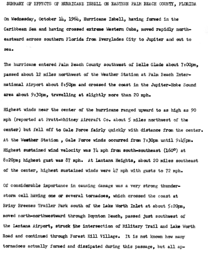
At 21:00 UTC on October 14, 1964, Hurricane Isbell made landfall near Everglades City as a Category 2 with maximum sustained winds of 105 mph (169 km/h),[26][27] having weakened somewhat from its estimated peak intensity of 115 mph (185 km/h).[28][29] It crossed South Florida in five and a half hours,[30] moving swiftly at 20 mph (32 km/h),[31] and entered the Atlantic Ocean in the Juno Beach–Jupiter area.[32] Top winds approached 90 mph (140 km/h) within a compact zone along the southeastern coast.[31] As Isbell headed northeast, a string of tornadoes—estimates of which ranged from 12 to 17[f][31][36]—formed in its right-front quadrant around the eye,[37] setting a contemporary record for hurricane-spawned tornadoes until Hurricane Beulah three years later.[36] Tornado activity centered mainly on coastal eastern Florida between Eau Gallie and Coral Gables,[34] causing 50 minor injuries,[38] which represented the entire storm total. The tornado series accounted for "a considerable portion"[g] of storm damage in South Florida, according to an official report.[32] At least one tornado family was verified, consisting of serial tornadoes fostered by a single thunderstorm.[40]
Confirmed tornadoes
| FU | F0 | F1 | F2 | F3 | F4 | F5 | Total |
|---|---|---|---|---|---|---|---|
| 0 | 0 | 5 | 4 | 0 | 0 | 0 | ≥ 9 |
| F# | Location | County / Parish | State | Start Coord.[i] | Time (UTC) | Path length | Width[j] | |
|---|---|---|---|---|---|---|---|---|
| F1 | Between Ochopee and Carnestown[k] | Collier | FL | 25°54′N 81°30′W / 25.9°N 81.5°W | 20:15–? | 0.1 mi (0.16 km) | 33 yd (30 m) | |
| A utility shed disintegrated and portions of the roof and siding were carried 300 ft (91 m). A chickee was flattened as well, and a cabin cruiser was moved 150 ft (46 m) into the nearby Everglades.[44] Losses totaled $250. The National Centers for Environmental Information (NCEI) list a touchdown point east-northeast of Dismal Key,[45] but Storm Data mentioned Carnestown.[32] | ||||||||
| F1 | Coral Gables | Dade | FL | 25°45′N 80°15′W / 25.75°N 80.25°W | ~20:30–?[l] | 0.1 mi (0.16 km) | 75 yd (69 m)[m] | |
| A brief, small tornado downed trees and power lines.[47][46] It also damaged three businesses,[48] shattering bottles and nine windows at a liquor store. At least one injury occurred.[46] Additionally, one or more homes sustained damage.[48] Losses totaled $2,500.[49] | ||||||||
| F1 | Boca Raton | Palm Beach | FL | 26°21′N 80°05′W / 26.35°N 80.08°W | 21:00–? | 0.1 mi (0.16 km) | 33 yd (30 m) | |
| A short-lived tornado struck a home, tearing off a screen enclosure. It also damaged nearby screens, awnings, windows, and shrubs.[50] Three injuries occurred. Losses totaled $2,500.[51] | ||||||||
| F1 | Boynton Beach | Palm Beach | FL | 26°32′N 80°04′W / 26.53°N 80.07°W | ~22:24–?[n] | 0.1 mi (0.16 km) | 33 yd (30 m) | |
| Related to the next event,[o][32] this tornado ripped off a few carports,[52]: 2 unroofing four homes.[53] Windows were broken as well, and many businesses were badly affected. A vehicle overturned, lightly injuring three occupants.[52]: 1 [54] Losses totaled $2,500.[55] | ||||||||
| F2 | Briny Breezes | Palm Beach | FL | 26°28′N 80°04′W / 26.47°N 80.07°W | 22:24–? | ≥ 0.1 mi (0.16 km)[p] | 100 yd (91 m) | |
| A strong tornado hit a trailer park,[32] impacting 25 trailers,[52]: 2 12 of which it razed,[q][53] along with power poles and trees.[52]: 1 The tornado curled erratically,[53] halving a trailer and casting it into a marina.[52]: 2 22 or more injuries occurred.[48] Losses totaled $250,000.[r][56] | ||||||||
| F1 | SW of Atlantis to Lake Worth Corridor to SW of Golden Lakes[s] | Palm Beach | FL | 26°43′N 80°04′W / 26.72°N 80.07°W | 23:00–? | ≥ 0.1 mi (0.16 km) | 33 yd (30 m) | |
| A sporadic tornado crossed Military Trail around SR 802,[57] ruining a tavern, breaking windows, and scattering liquor. It also smashed garage doors, tipped semi-trucks onto their sides, damaged a fire station, and felled trees and poles. Damage to homes was mostly cosmetic, limited to roofing and ceilings. Furniture, a lawn mower, and an automobile were tossed. Signs were blown down at the South Florida Fair.[52]: 2 Three people were injured. Losses totaled $25,000.[58] | ||||||||
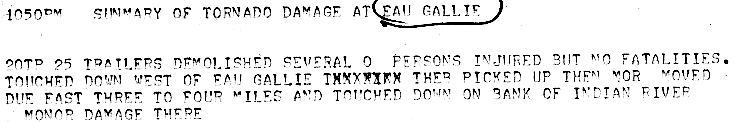
| F2 | Eau Gallie | Brevard | FL | 28°08′N 80°38′W / 28.13°N 80.63°W | 01:20–? | ≥ 0.1 mi (0.16 km)[t] | 33 yd (30 m) | |
| A tornado leveled over 12 trailers,[48] unroofing a church and three homes.[39]: 1 [53] A home was thrown over a street, hitting a car and another home. It landed 100 yd (91 m) away.[48] 17 minor occurred. Losses totaled $250,000.[u][60] | ||||||||
| F2 | Hobe Sound | Martin | FL | 27°03′N 80°07′W / 27.05°N 80.12°W | 02:15–?[v] | 0.1 mi (0.16 km) | 33 yd (30 m) | |
| Forming alongside U.S. Route 1,[32] this tornado unroofed three trailers, lofting debris 300 ft (91 m).[61] It also mangled a garage, half a citrus stand, and several dozen pines.[62] Losses totaled $2,500.[63] Grazulis did not list the tornado, implying a lower rating than F2.[53] | ||||||||
| F2 | NW of Dania Beach to Sunrise[w] | Broward | FL | 26°04′N 80°12′W / 26.07°N 80.2°W | 03:50–? | ≥ 0.1 mi (0.16 km) | 33 yd (30 m) | |
| A tornado struck Fort Lauderdale–Hollywood International Airport, damaging half a dozen light aircraft, razing a home, and downing trees.[64] Three airplanes were torn from their tie-downs.[48] The tornado also unroofed a nearby clubhouse at a country club.[53] Losses totaled $25,000.[66] | ||||||||
Other tornadoes
An Associated Press dispatch stated that half a dozen tornadoes hit Palm Beach County and three more in Dade County.[67] A tornado reportedly hit Belle Glade, wrecking several trailers and downing trees on U.S. Route 441.[68][65] Another tornado struck a microwave tower in Loxahatchee.[48] Multiple tornadoes damaged various buildings in Lake Worth.[39]: 2 A tornado also caused a trailer collision in Stuart,[62] piling up wreckage.[61] Official records do not show these tornadoes, however.[69]
See also
- List of North American tornadoes and tornado outbreaks
- Hurricane Agnes tornado outbreak – Deadliest Florida outbreak linked to a tropical cyclone
- Hurricane Milton tornado outbreak – Generated more Florida tornadoes than any other tropical cyclone
- Tropical Storm Debby (2012) – Also produced many tornadoes over South Florida
Notes
- ^ All losses are in 1964 United States dollars unless otherwise noted.
- ^ Scientists under Ted Fujita devised the F-scale in the early 1970s, prior to which no official scheme existed in the United States.[6][7] U.S. tornadoes were ranked first in 1971,[6][7] with ratings applied retroactively to events before the use of the F-scale by the National Weather Service. Ratings were assigned back to 1950, but tornado expert Thomas P. Grazulis evaluated older events.[8] Superseded in the U.S. by the EF-scale as of February 1, 2007,[9] the F-scale was used by Canada until April 1, 2013;[10] other states, like the United Kingdom, employ proxies such as the TORRO scale.[11]
- ^ Florida winter (November–April) coincides with the dry season.[15]
- ^ Called outbreaks, these contain at least four to six tornadoes within set timescales, often six-hour, that vary by region. In Florida four-hour intervals delimit outbreaks.[18][19]
- ^ A 1998 study found that severe episodes—with at least one E/F3+ or killer tornado, or a 24-hour group of five including one or more E/F2 tornadoes—tied to these systems favored inactive Atlantic hurricane seasons with lower Cape Verde hurricane incidence.[21]
- ^ Multiple sources listed 11 or more,[33][34] and the National Hurricane Center in its annual report noted "at least" 13,[35] though the official total was nine.
- ^ In Palm Beach County almost half of all storm-related losses were tied to tornadoes.[35] The Cocoa Tribune ascribed most of them to tornadoes.[39]: 2
- ^ All dates are based on the local time zone where the tornado touched down; however, all times are in Coordinated Universal Time and dates are split at midnight CST/CDT for consistency.
- ^ Coordinates are taken from the NCEI database and may not reflect contemporary analyses.
- ^ The values listed are mainly the average/mean, with known maximum widths denoted by ♯. From 1952 to 1994, reports largely list mean width whereas current years list maximum width.[41] Values adopted by Grazulis are the average width, with estimates being rounded down (i.e. 0.5 mi (0.80 km) is rounded down from 880 yards to 800 yards).[42][43]
- ^ According to the Fort Myers News-Press[44]
- ^ According to the Miami Herald[46]
- ^ Accordin to Storm Data[32]
- ^ According to the Palm Beach Post[52]: 1
- ^ Grazulis merged both tornadoes.[53]
- ^ News media and Grazulis cited a 1-mile (1.6 km) path.[53][52]: 2
- ^ Another source listed 20.[48]
- ^ A local mayor listed $150,000.[39]: 2
- ^ According to the Palm Beach Post[52]: 2
- ^ One report noted a length of 3 to 4 mi (4.8 to 6.4 km).[59]
- ^ Local media listed $100,000.[39]: 1
- ^ According to the Stuart News[61]
- ^ According to the Fort Lauderdale Daily News[64][65]
References
- Citations
- ^ "Tornadoes". Florida Climate Center. Tallahassee, Florida: Florida State University. Retrieved July 19, 2025.
- ^ Donegan, Brian (March 21, 2022). "Where are tornadoes most common?". FOX Weather. Retrieved May 12, 2025.
- ^ Winsberg 1990, pp. 68–70.
- ^ a b Winsberg 2003, p. 90.
- ^ a b Grazulis 1993, p. 141.
- ^ a b Grazulis 2001a, p. 131.
- ^ Edwards, LaDue & Ferree, p. 641–643.
- ^ Edwards, Roger (March 5, 2015). "Enhanced F Scale for Tornado Damage". The Online Tornado FAQ (by Roger Edwards, SPC). Storm Prediction Center. Retrieved February 25, 2016.
- ^ "Enhanced Fujita Scale (EF-Scale)". Environment and Climate Change Canada. Environment and Climate Change Canada. June 6, 2013. Archived from the original on March 3, 2016. Retrieved February 25, 2016.
- ^ "The International Tornado Intensity Scale". Tornado and Storm Research Organisation. Tornado and Storm Research Organisation. 2016. Archived from the original on March 5, 2016. Retrieved February 25, 2016.
- ^ a b Gregoria, Dan. "WFO Miami, Florida severe weather climatology" (PDF). NWS Forecast Office Miami - South Florida. Miami: National Weather Service. Archived from the original (PDF) on September 25, 2008. Retrieved June 1, 2008.
- ^ Hagemeyer, Bartlett C.; Hodanish, Stephen J. (1995). Written at Melbourne, Florida. Florida Tornado Outbreaks Associated With Tropical Cyclones. 21st Conference on Hurricanes and Tropical Meteorology. Miami: American Meteorological Society. Archived from the original on June 17, 2008. Retrieved November 24, 2019.
- ^ Lushine, James B. (November 1, 2005). "Summary of Severe Weather Outbreak in South Florida: February 2, 1998". NWS Forecast Office Miami - South Florida. Miami: National Weather Service. Archived from the original on July 24, 2008. Retrieved June 9, 2008.
- ^ Hagemeyer, Bartlett C. (August 10, 2010). "Florida Dry Season Forecast and El Niño-Southern Oscillation (ENSO)". Melbourne, FL Weather Forecast Office. Melbourne, Florida: National Weather Service. Retrieved July 19, 2025.
- ^ Hagemeyer, Barlett C. (2000). Written at Melbourne, Florida. Development of an index of storminess as a proxy for dry season severe weather in Florida and its relationship with ENSO (PDF). 20th Conference on Severe Local Storms. Orlando, Florida: National Weather Service. Archived from the original (PDF) on February 25, 2014. Retrieved October 7, 2021.
- ^ Hagemeyer, Barlett C. (1998). Written at Melbourne, Florida. Significant Extratropical Tornado Occurrences in Florida During Strong El Niño and Strong La Niña Events (PDF). 19th Conference on Severe Local Storms. Minneapolis: National Weather Service. Archived from the original (PDF) on February 25, 2014. Retrieved October 7, 2021.
- ^ Hagemeyer, pp. 399, 400–1, 404.
- ^ Hagemeyer, Bartlett C.; Spratt, Scott M. (2002). Written at Melbourne, Florida. Thirty Years After Hurricane Agnes: the Forgotten Florida Tornado Disaster (PDF). 25th Conference on Hurricanes and Tropical Meteorology. San Diego, California: American Meteorological Society. Archived from the original (PDF) on October 16, 2008. Retrieved July 28, 2025.
- ^ Hagemeyer, p. 405.
- ^ Hagemeyer, Bartlett C. (1998). Written at Melbourne, Florida. 1.2 Significant Tornado Events Associated with Tropical and Hybrid Cyclones in Florida. 16th Conference on Weather Analysis and Forecasting. Phoenix, Arizona: American Meteorological Society. Archived from the original on June 16, 2004. Retrieved November 24, 2019.
- ^ Hagemeyer, p. 401.
- ^ Hagemeyer, p. 403.
- ^ Agee & Childs, p. 1496.
- ^ Cook & Schaefer, p. 3135.
- ^ Landsea, Chris; Anderson, Craig; Bredemeyer, William; et al. (September 2025). Detailed List of Continental United States Hurricane Impacts/Landfalls 1851–1970, 1983–2024. Re-Analysis Project (Report). Miami, Florida: Atlantic Oceanographic and Meteorological Laboratory, Hurricane Research Division.
- ^ Hurricane Research Division (February 2008). "Chronological List of All Hurricanes which Affected the Continental United States: 1851–2007". National Hurricane Center. National Oceanic and Atmospheric Administration. Archived from the original (.TXT) on September 21, 2008. Retrieved June 18, 2014.
- ^ "Atlantic hurricane best track (HURDAT version 2)" (Database). United States National Hurricane Center. April 4, 2025. This article incorporates text from this source, which is in the public domain.
- Landsea, Chris (April 2022). "The revised Atlantic hurricane database (HURDAT2) - Chris Landsea – April 2022" (PDF). Hurricane Research Division – NOAA/AOML. Miami, Florida: Hurricane Research Division – via Atlantic Oceanographic and Meteorological Laboratory.
- ^ IBTrACS 2021, 1964283N15277.
- ^ Dunn, p. 186.
- ^ a b c Butson, p. 128.
- ^ a b c d e f g Storm Data 1964, p. 106.
- ^ Dunn, pp. 186–7.
- ^ a b Barnes.
- ^ a b U.S. Weather Bureau (October 1964). Hurricane Isbell - October 12 – 16, 1964. Miami – South Florida Weather Forecast Office (Report). Miami: National Weather Service. Retrieved March 18, 2026.
- ^ a b Storm Data 1967, p. 122.
- ^ Hagemeyer, p. 415.
- ^ Dunn, p. 187.
- ^ a b c d e "Dozen Trailers Flipped". Cocoa Tribune. Vol. 48, no. 153. October 15, 1964. p. 1 – via Newspapers.com.
- ^ Hudnall, Jack L. Summary of Effects of Hurricane Isbell on Eastern Palm Beach County, Florida (Report). Retrieved March 20, 2026 – via Storm Wallets.
- ^ Agee & Childs, p. 1494.
- ^ Brooks, p. 310.
- ^ Grazulis 1990, p. ix.
- ^ a b Winter, Fred G. (October 16, 1964). Written at Naples, Florida. "Hurricane Isbell Damage Runs Half-Million in Collier County". Fort Myers News-Press. Vol. 80. Fort Myers, Florida. p. 1B. Retrieved July 2, 2020 – via National Hurricane Center.
- ^ Storm Data Publication 1964, #9988786.
- ^ a b c Cook, Lou; Reno, Henry (October 15, 1964). "'The Noise Made Cleo Seem Mild'". Miami Herald. Vol. 54, no. 319 (Air Express ed.). p. 1A – via Newspapers.com.
- ^ Colbert, Haines (October 15, 1964). "Eye Passes Over Everglades City in Collier County". Miami Herald. Vol. 54, no. 319 (Air Express ed.). p. 1A – via Newspapers.com.
- ^ a b c d e f g h Written at Miami. "Hurricane Moves Across Florida". New York Times. Vol. 114, no. 38981. New York City (published October 15, 1964). Associated Press. October 14, 1964. p. 17. ProQuest 115595515. Retrieved March 19, 2026.
- ^ Storm Data Publication 1964, #9988785.
- ^ "Isbell Ploughs Through Glades West of City" (PDF). Boca Raton News. Vol. 9, no. 47. Boca Raton, Florida: Boca Raton Historical Society and Museum. October 15, 1964. pp. 1A. Retrieved March 19, 2026.
- ^ Storm Data Publication 1964, #9988787.
- ^ a b c d e f g h i "Storm Hits Hardest in Briny Breezes". Palm Beach Post. Vol. 56, no. 211. October 15, 1964. p. 1 – via Newspapers.com.
- ^ a b c d e f g h Grazulis 1993, p. 1057.
- ^ "Twisters Spin Havoc In South PB County". Fort Lauderdale Daily News. October 15, 1964. p. 1B – via Newspapers.com.
- ^ Storm Data Publication 1964, #9988788.
- ^ Storm Data Publication 1964, #9988790.
- ^ Storm Data 1964, p. 107.
- ^ Storm Data Publication 1964, #9988791.
- ^ Summary of Tornado Damage at Eau Gallie (Report). National Hurricane Center. Retrieved March 20, 2026 – via Storm Wallets.
- ^ Storm Data Publication 1964, #9988792.
- ^ a b c "Twisters in Hurricane Hit Trailers, Homes in County". The Stuart News. Vol. 28, no. 13. October 22, 1964. p. 1-C – via Newspapers.com.
- ^ a b Minter, Jim (October 16, 1964). "Tornado Shatters Garage". Miami Herald. p. 1C – via Newspapers.com.
- ^ Storm Data Publication 1964, #9988789.
- ^ a b "Scars Remain In North Broward". Fort Lauderdale Daily News. October 15, 1964. p. 1B – via Newspapers.com.
- ^ a b Wieland, Ray (October 15, 1964). "Twisters Hurt 39 In State". Fort Lauderdale Daily News. p. 14A – via Newspapers.com.
- ^ Storm Data Publication 1964, #9988793.
- ^ "Hurricane May Miss Carolinas". Tampa Tribune. Vol. 70, no. 290 (Florida ed.). Associated Press. October 16, 1964. p. 4-A – via Newspapers.com.
- ^ Nachman, Iz (October 16, 1964). "Sweet Corn Crop Seriously Damaged". Palm Beach Post. Vol. 56, no. 212. p. 7 – via Newspapers.com.
- ^ Storm Data 1964, pp. 106–7.
- Sources
- Agee, Ernest M.; Childs, Samuel (June 1, 2014). "Adjustments in Tornado Counts, F-Scale Intensity, and Path Width for Assessing Significant Tornado Destruction". Journal of Applied Meteorology and Climatology. 53 (6). American Meteorological Society: 1494–1505. Bibcode:2014JApMC..53.1494A. doi:10.1175/JAMC-D-13-0235.1.
- Barnes, Jay (1998). "Hurricanes in the Sunshine State, 1900–1949". Florida's Hurricane History (1st ed.). Chapel Hill: UNC Press. pp. 222–3. ISBN 0-8078-2443-7 – via Internet Archive.
- Brooks, Harold E. (April 2004). "On the Relationship of Tornado Path Length and Width to Intensity". Weather and Forecasting. 19 (2): 310–19. Bibcode:2004WtFor..19..310B. doi:10.1175/1520-0434(2004)019<0310:OTROTP>2.0.CO;2.
- Butson, Keith (October 1964). Written at Gainesville, Florida. "Florida – October 1964". Florida section. Climatological Data. 30 (9). Washington, D.C.: United States Department of Commerce: 128–9 – via National Centers for Environmental Information.
- Cook, A. R.; Schaefer, J. T. (August 2008). "The Relation of El Niño–Southern Oscillation (ENSO) to Winter Tornado Outbreaks". Monthly Weather Review. 136 (8): 3121–3137. Bibcode:2008MWRv..136.3121C. doi:10.1175/2007MWR2171.1.
- Edwards, Roger; LaDue, James G.; Ferree, John T.; et al. (May 1, 2013). "Tornado Intensity Estimation: Past, Present, and Future". Bulletin of the American Meteorological Society. 94 (5). American Meteorological Society: 641–653. doi:10.1175/BAMS-D-11-00006.1.
- Dunn, Gordon (March 1965). "The Hurricane Season of 1964". Monthly Weather Review. 93 (3). United States Weather Bureau: 175–187. Bibcode:1965MWRv...93..175D. doi:10.1175/1520-0493(1965)093<0175:THSO>2.3.CO;2. ISSN 1520-0493.
- Grazulis, Thomas P. (November 1990). Significant Tornadoes 1880–1989. Vol. 2. St. Johnsbury, Vermont: The Tornado Project of Environmental Films. ISBN 1-879362-02-3.
- — (July 1993). Significant Tornadoes 1680–1991: A Chronology and Analysis of Events. St. Johnsbury, Vermont: The Tornado Project of Environmental Films. ISBN 1-879362-03-1.
- — (2001a). The Tornado: Nature's Ultimate Windstorm. Norman: University of Oklahoma Press. ISBN 978-0-8061-3538-0.
- Hagemeyer, Bartlett C. (September 1997). "Peninsular Florida Tornado Outbreaks". Weather and Forecasting. 12 (3). Boston: American Meteorological Society: 399–426. Bibcode:1997WtFor..12..399H. doi:10.1175/1520-0434(1997)012<0399:PFTO>2.0.CO;2 – via Zenodo.
- International Best Track Archive for Climate Stewardship (IBTrACS) (May 2021). IBTrACS browser (hosted by UNC Asheville) (Report). National Centers for Environmental Information – via World Data Center for Meteorology.
- National Weather Service (October 1964). Storm Data Publication (Report). National Centers for Environmental Information – via Storm Events Database.
- U.S. Weather Bureau (October 1964). "Storm Data and Unusual Weather Phenomena". Storm Data. 6 (10). Asheville, North Carolina: United States Department of Commerce – via National Centers for Environmental Information.
- U.S. Weather Bureau (September 1967). "Storm Data and Unusual Weather Phenomena". Storm Data. 9 (9). Asheville, North Carolina: United States Department of Commerce – via National Centers for Environmental Information.
- Winsberg, Morton D. (1990). Florida Weather (1st ed.). Orlando, Florida: University of Central Florida Press. ISBN 0-8130-0989-8 – via Internet Archive.
- — (2003) [1990]. Florida Weather (2nd ed.). Gainesville: University Press of Florida. ISBN 0-8130-2684-9 – via Internet Archive.